pacman::p_load(tidyverse, rnaturalearth, sf)13 Human geography lab 4
- Load all necessary packages
We use free data on world map: Natural Earth
Using
rnaturalearthpackage, we get the data necessary to draw a world mapName the data world_map
global_map <- ne_countries(scale = "small", returnclass = "sf")- Show the list of variables included global_map
names(global_map) [1] "featurecla" "scalerank" "labelrank" "sovereignt" "sov_a3"
[6] "adm0_dif" "level" "type" "tlc" "admin"
[11] "adm0_a3" "geou_dif" "geounit" "gu_a3" "su_dif"
[16] "subunit" "su_a3" "brk_diff" "name" "name_long"
[21] "brk_a3" "brk_name" "brk_group" "abbrev" "postal"
[26] "formal_en" "formal_fr" "name_ciawf" "note_adm0" "note_brk"
[31] "name_sort" "name_alt" "mapcolor7" "mapcolor8" "mapcolor9"
[36] "mapcolor13" "pop_est" "pop_rank" "pop_year" "gdp_md"
[41] "gdp_year" "economy" "income_grp" "fips_10" "iso_a2"
[46] "iso_a2_eh" "iso_a3" "iso_a3_eh" "iso_n3" "iso_n3_eh"
[51] "un_a3" "wb_a2" "wb_a3" "woe_id" "woe_id_eh"
[56] "woe_note" "adm0_iso" "adm0_diff" "adm0_tlc" "adm0_a3_us"
[61] "adm0_a3_fr" "adm0_a3_ru" "adm0_a3_es" "adm0_a3_cn" "adm0_a3_tw"
[66] "adm0_a3_in" "adm0_a3_np" "adm0_a3_pk" "adm0_a3_de" "adm0_a3_gb"
[71] "adm0_a3_br" "adm0_a3_il" "adm0_a3_ps" "adm0_a3_sa" "adm0_a3_eg"
[76] "adm0_a3_ma" "adm0_a3_pt" "adm0_a3_ar" "adm0_a3_jp" "adm0_a3_ko"
[81] "adm0_a3_vn" "adm0_a3_tr" "adm0_a3_id" "adm0_a3_pl" "adm0_a3_gr"
[86] "adm0_a3_it" "adm0_a3_nl" "adm0_a3_se" "adm0_a3_bd" "adm0_a3_ua"
[91] "adm0_a3_un" "adm0_a3_wb" "continent" "region_un" "subregion"
[96] "region_wb" "name_len" "long_len" "abbrev_len" "tiny"
[101] "homepart" "min_zoom" "min_label" "max_label" "label_x"
[106] "label_y" "ne_id" "wikidataid" "name_ar" "name_bn"
[111] "name_de" "name_en" "name_es" "name_fa" "name_fr"
[116] "name_el" "name_he" "name_hi" "name_hu" "name_id"
[121] "name_it" "name_ja" "name_ko" "name_nl" "name_pl"
[126] "name_pt" "name_ru" "name_sv" "name_tr" "name_uk"
[131] "name_ur" "name_vi" "name_zh" "name_zht" "fclass_iso"
[136] "tlc_diff" "fclass_tlc" "fclass_us" "fclass_fr" "fclass_ru"
[141] "fclass_es" "fclass_cn" "fclass_tw" "fclass_in" "fclass_np"
[146] "fclass_pk" "fclass_de" "fclass_gb" "fclass_br" "fclass_il"
[151] "fclass_ps" "fclass_sa" "fclass_eg" "fclass_ma" "fclass_pt"
[156] "fclass_ar" "fclass_jp" "fclass_ko" "fclass_vn" "fclass_tr"
[161] "fclass_id" "fclass_pl" "fclass_gr" "fclass_it" "fclass_nl"
[166] "fclass_se" "fclass_bd" "fclass_ua" "geometry" - We see 169 variables
- Check the class of global_map
- If you want to see the data of GDP for each country, use following code:
global_map %>%
select(sovereignt, gdp_md, gdp_year) %>%
DT::datatable()- World is a GeoDataFrame with the following columns:
pop_est: Contains a population estimate for the country
continent: The country’s continent
name_en: The country’s name in English
iso_a3: The country’s 3 letter abbreviation (we made this the index)
gdp_md: A country’s GDP in million dollar
geometry: A POLYGON for each country (we will learn more about these soon)
class(global_map)[1] "sf" "data.frame"- global_map has two classes: sf & data.frame
13.1 Global GDP map
global_map %>%
  ggplot() +
  geom_sf(aes(fill = gdp_md)) +
  scale_fill_gradient(low = "white", high = "green") +
  labs(fill = "GDP") +
  theme_minimal(base_family = "HiraKakuProN-W3") +
  theme(legend.position = "bottom")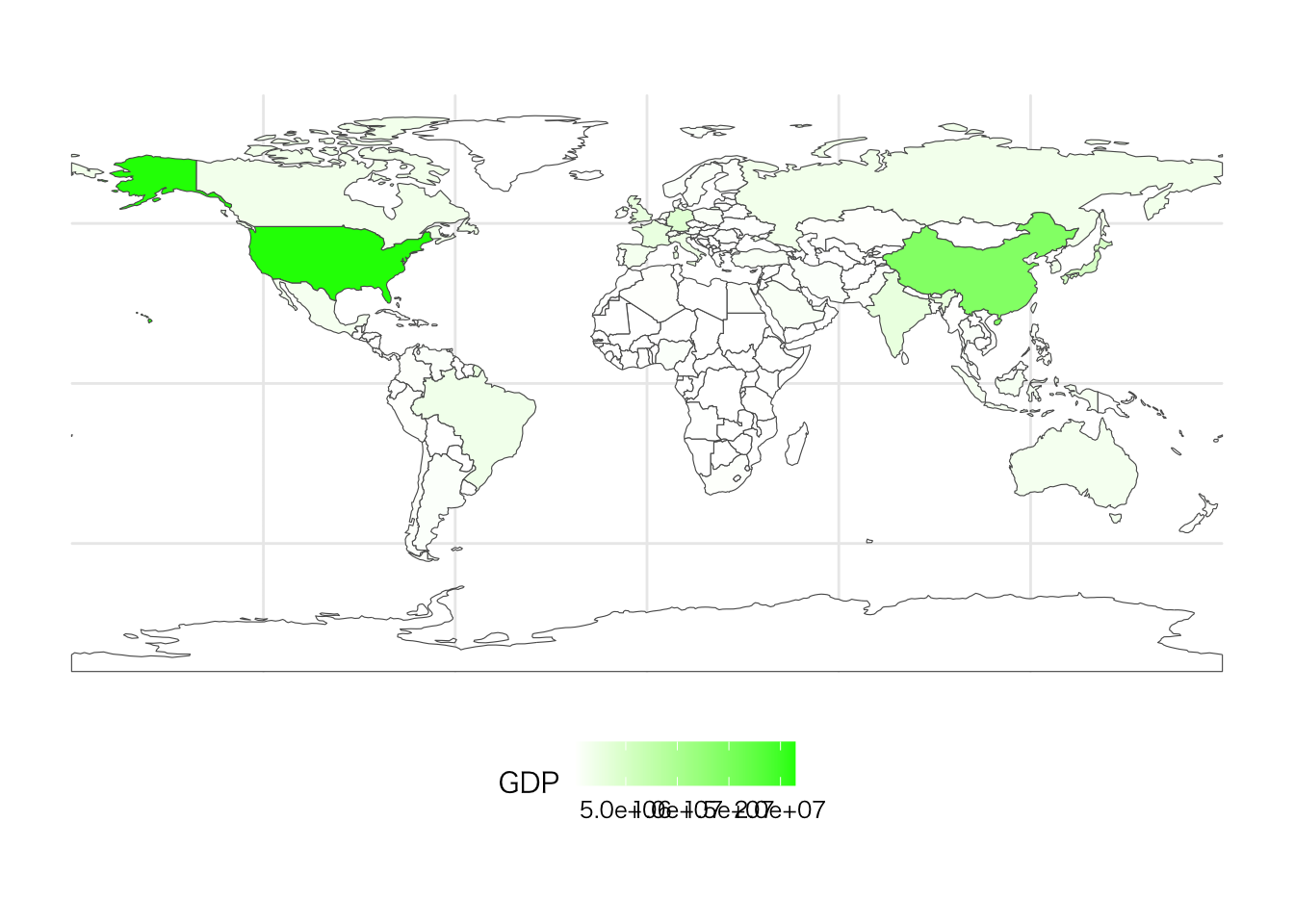
- Let’s change the color and the position of legend.
global_map %>%
  ggplot() +
  geom_sf(aes(fill = gdp_md)) +
  scale_fill_gradient(low = "gray", high = "blue") +
  labs(fill = "GDP_2019") +
  theme_minimal(base_family = "HiraKakuProN-W3") +
  theme(legend.position = "left")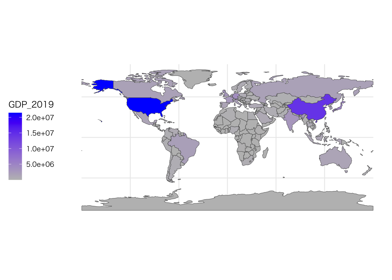
13.2 Regional GDP map
- GDP of European countries in 2019
global_map %>%
  ggplot() +
  geom_sf(aes(fill = gdp_md)) +
  scale_fill_gradient(low = "white", high = "green") +
  labs(fill = "GDP_Europe") +
  coord_sf(xlim = c(-10, 45), ylim = c(35, 60)) +
  theme_minimal(base_family = "HiraKakuProN-W3") +
  theme(legend.position = "left")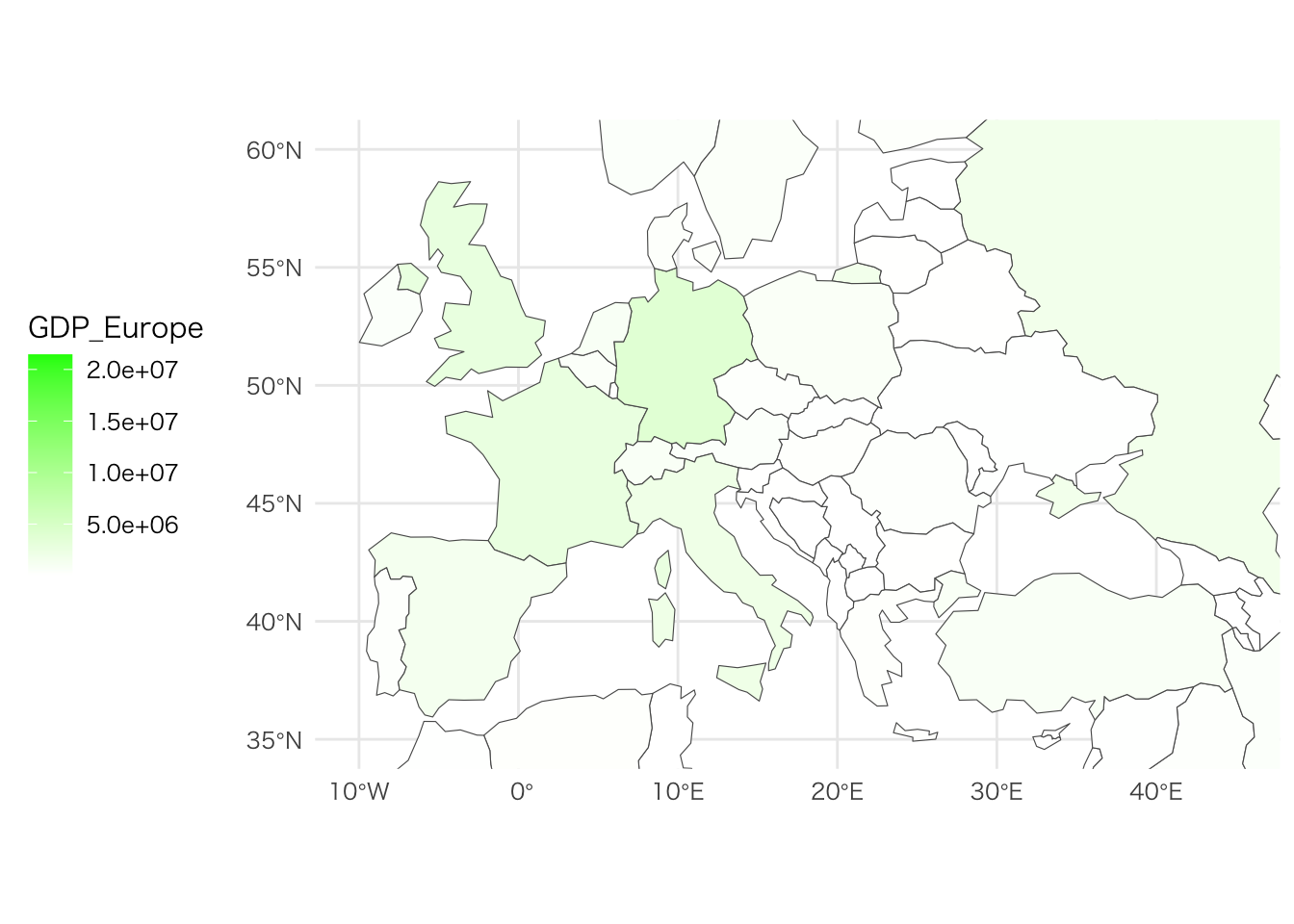
- GDP of African countries in 2019
global_map %>%
  ggplot() +
  geom_sf(aes(fill = gdp_md)) +
  scale_fill_gradient(low = "white", high = "green") +
  labs(fill = "GDP_Africa") +
  coord_sf(xlim = c(-30, 60), ylim = c(-40, 40)) +
  theme_minimal(base_family = "HiraKakuProN-W3") +
  theme(legend.position = "left")